Distribuie


Adaugat la data de 3 Aug 2014 11:18 - ID: 668564
DESCRIERE
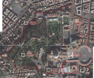
S.C. GEORESEARCH S.R.L. develops and sells administrative map with height precision in vector format of Vatican.
The map was vectoring after satellite images in Transverse Mercator projection, scale 1:2, 440 and considering the cadastral map of the city of Rome at 1:2, 000 scale.
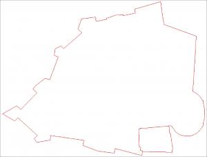
Coordinates were taken after satellite images from 1:500 to within 0.12 m. Geographic projection system coordinates in WGS 84 ellipsoid on were redesigned in UTM projection system 33 N on WGS 84 ellipsoid.
The precision with which they were vectorized boundary points is 0.2 m.
So, the final error determination of Vatican boundary points is 0.32 m, better than what is achieved by 1:2, 000 scale maps.
Shapefile contains the Vatican boundary as the Lateran Agreement, and the nearest extraterritorial property of the Vatican.
Vatican area in UTM 33 N coordinate projection system is 49.26 ha.
Coordinate projection system: UTM
Projection: UTM zone 33 N
Ellipsoid: WGS 84
File format: Autocad dwg, ESRI shapefile
Availability: Over 1 day
The map was vectoring after satellite images in Transverse Mercator projection, scale 1:2, 440 and considering the cadastral map of the city of Rome at 1:2, 000 scale.
Coordinates were taken after satellite images from 1:500 to within 0.12 m. Geographic projection system coordinates in WGS 84 ellipsoid on were redesigned in UTM projection system 33 N on WGS 84 ellipsoid.
The precision with which they were vectorized boundary points is 0.2 m.
So, the final error determination of Vatican boundary points is 0.32 m, better than what is achieved by 1:2, 000 scale maps.
Shapefile contains the Vatican boundary as the Lateran Agreement, and the nearest extraterritorial property of the Vatican.
Vatican area in UTM 33 N coordinate projection system is 49.26 ha.
Coordinate projection system: UTM
Projection: UTM zone 33 N
Ellipsoid: WGS 84
File format: Autocad dwg, ESRI shapefile
Availability: Over 1 day
IMAGINI
LOCALIZARE PE HARTA
MESAJ
COMENTARII SI RECENZII

Home · Adauga anunt · Modifica anunt · Login · Inregistrare firma · Forum · Widget anunturi · Semnalati o neregula · Contactati echipa Anunturi AZ ·
Index produse: A B C D E F G H I J K L M N O P Q R S T U V X Y Z
Va doriti propriile produse listate aici ? Creati-va propriul magazin virtual pe aaz.ro.
Informatiile despre preturi, produse si servicii sunt oferite de terte parti si doar pentru informare. AAZ.ro nu garanteaza acuratetea informatiilor si nu este raspunzator pentru nici o eroare, omisiune sau intarzieri,
nici pentru orice neintelegeri sau pierderi datorita acestor informatii. Termeni si conditii | Politica de confidentialitate | Stergerea contului | Cookies | Siguranta online | ANPC | Contact


AAZ.ro © 2008
Index produse: A B C D E F G H I J K L M N O P Q R S T U V X Y Z
Descarca gratuit aplicatia pentru telefonul tau

Va doriti propriile produse listate aici ? Creati-va propriul magazin virtual pe aaz.ro.
Informatiile despre preturi, produse si servicii sunt oferite de terte parti si doar pentru informare. AAZ.ro nu garanteaza acuratetea informatiilor si nu este raspunzator pentru nici o eroare, omisiune sau intarzieri,
nici pentru orice neintelegeri sau pierderi datorita acestor informatii. Termeni si conditii | Politica de confidentialitate | Stergerea contului | Cookies | Siguranta online | ANPC | Contact
AAZ.ro © 2008